INTRODUCTION
West Antarctica is one of the most rapidly warming regions on Earth. This warming is closely connected with global sea level rise. The discovery of rapid climate change on the West Antarctic Ice Sheet (WAIS) challenges previous explanations of Antarctic climate change that focused on strengthening of circumpolar westerlies in response to the positive polarity trend in the Southern Annular Mode. West Antarctic warming does not yet have a comprehensive explanation: dynamical mechanisms may vary from one season to the next, and these mechanisms very likely involve complex teleconnections with subtropical and tropical latitudes. The prime motivation for the AWARE Mission is to resume climatological field work, since there has been no substantial atmospheric science or climatological field work on West Antarctica since that started during the 1957 International Geophysical Year (and continued for just a few years afterward).

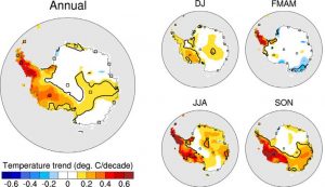
Linear trends in Antarctic near-surface temperature calculated for the 1958 – 2011 period and based on spatially interpolated monthly temperatures (Nicolas and Bromwich, 2014). The squares denote the locations of the 15 stations used as anchor points for the spatial interpolation. The thick black lines encompass the areas where the trends are statistically significant at 95%.
Linear trends in Antarctic near-surface temperature calculated for the 1958 – 2011 period and based on spatially interpolated monthly temperatures (Nicolas and Bromwich, 2014). The squares denote the locations of the 15 stations used as anchor
points for the spatial interpolation. The thick black lines encompass the areas where the trends are statistically significant at 95%.
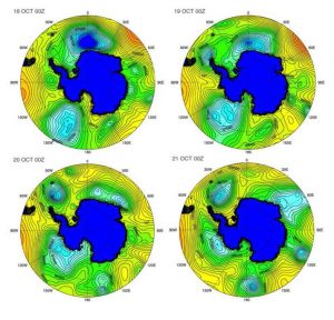
ERA-Interim sea level pressure from 18-21 October 2012, showing the progress of a trough heading into the Ross and Amundsen Seas and then dissipating with an eastward trajectory along West Antarctica. (Scott and Lubin, 2014)
For several decades, direct meteorological information on the WAIS has been limited to a few automatic weather stations. And yet satellite imagery and meteorological reanalyses indicate that West Antarctica is highly susceptible to advection of warm and moist maritime air, with related cloud cover, depending on the location and strength of low pressure cells in the Amundsen, Ross, and Bellingshausen Seas. There is a need to quantify the role of these changing air masses on the surface energy balance, including all surface energy components and cloud radiative forcing.

ERA-Interim sea level pressure from 18-21 October 2012, showing the progress of a trough heading into the Ross and Amundsen Seas and then dissipating with an eastward trajectory along West Antarctica. (Scott and Lubin, 2014)
Generally, global climate model simulations are known to perform poorly over the Antarctic and Southern Ocean, and the marked scarcity of cloud information at Southern high latitudes has so far inhibited significant progress. Fortunately, McMurdo Station, where ARM’s most advanced cloud and aerosol instrumentation is situated, has a meteorological relationship with the WAIS via circulation patterns in the Ross and Amundsen Seas. Therefore, we gather sophisticated data with cloud radars and high spectral resolution lidar, and a complete aerosol suite, at McMurdo, that have relevance to the WAIS as well. At the same time, we send basic radiometric, surface energy balance, and upper air equipment directly to the WAIS to make the first well-calibrated climatological suite of measurements seen in this extremely remote, but globally critical region, in more than forty years.
Using the original concept of ARM field measurements, we refer to the McMurdo deployment of the AMF2 as our Central Facility, and the additional equipment sent to the WAIS as our Extended Facility. Our AWARE Mission subset of instruments for the WAIS is chosen to realistically accommodate the LC-130 (Ski Hercules) transport aircraft flights that can reach the site.
Data analyzed from this Antarctic AMF deployment in three thrusts:
(1) provide quantitative information on WAIS energy balance components and cloud radiative forcing as they relate to changing air masses and warm air advection, which are ultimately related to lower latitude teleconnections;
(2) provide cloud microphysical data to evaluate and improve climate model performance in the coldest and most pristine environment on Earth, particularly with respect to the orographically-induced high vertical velocities that give rise to larger cloud ice water amounts over Antarctica; and
(3) fully characterize an annual cycle of aerosol properties combining the microphysical information from AMF2 with chemical composition analysis of samples performed at UCSD Scripps Institution of Oceanography (SIO).
SCIENCE OBJECTIVES
The primary objective of AWARE on the WAIS is to characterize the atmospheric and surface energy budget, and atmospheric thermodynamic structure as completely as possible with available logistics and instrumentation, in order to garner a data set that can be interpreted in the context of large-scale atmospheric dynamics. These outcomes will help us to understand specific warming mechanisms over West Antarctica. The primary objectives of AWARE at McMurdo are
(1) to empirically understand the unique Antarctic manifestations of mixed-phase clouds and aerosols, and their effect on the radiation budget, and
(2) using the most advanced atmospheric instrumentation available, examine microphysical properties of clouds that have recently descended from the WAIS to Ross Island via the Ross Ice Shelf. These goals require measurements of the following:
a) Surface energy balance including downwelling and upwelling shortwave and longwave radiation, and surface fluxes of momentum, moisture, precipitation, and latent and sensible heat.
b) Spectral downwelling radiation measurements in the shortwave and longwave, to relate cloud microphysical properties and atmospheric aerosol and moisture content to the broadband radiation components at the surface, and in to make independent retrievals of cloud optical properties for closure study in comparison with the active sensor data.
c) A complete inventory of cloud properties, including the basic properties of cloud type, cloud fraction, cloud base and geometrical thickness (WAIS and McMurdo), and more advanced and altitude-dependent measurements of cloud particle size distribution, thermodynamic phase, cloud particle vertical velocity, and precipitation rate and type (McMurdo).
d) A complete inventory of aerosol properties (McMurdo) including chemical composition, particle size distribution, cloud condensation nuclei (CCN) behavior, hygroscopic behavior, and light scattering properties.
e) The atmospheric state, including surface measurements and vertical profiles of temperature, pressure, relative humidity, wind speed and direction.
MEASUREMENT REQUIREMENTS
At McMurdo, measurements from the full suite of AMF2 instruments can be made essentially as at any land site where the AMFs have been situated, although there are some unique logistical challenges and minor restrictions on instrument operation to avoid radar interference with other station activities (see logistics section below).
At the WAIS, we deploy the most complete suite of instruments possible that can be operated from one small container and with power available at that small, summer-only research station. Because of the need to relate the WAIS energy budget measurements to large-scale dynamics, we emphasize vertical profiling, both with a microwave vertical profiling radiometer and with sondes. The normal schedule for sondes at WAIS is at least twice daily, at 00:00 and 12:00 UTC, but we have a reserve so that we can increase to four times daily (00:00, 06:00, 12:00, 18:00) during intensive operation periods (IOPs) that may merge. One example of an IOP would be a warm, moist airmass being advected over West Antarctica from the Southern Ocean, with a concomitant change in vertical profiles of temperature, moisture, and cloud properties. An IOP over the WAIS can only be identified by daily monitoring of large-scale atmospheric transport through global and regional modeling that Dr. David Bromwich does at Byrd Polar Research Center (BPRC); therefore we perform daily communication with the WAIS station to adjust the sonde schedule as necessary.
INSTRUMENTS
Follow the link here of two tables showing the list of instruments deployed at WAIS and McMurdo. Much of the WAIS equipment contains duplicate (additional) instruments of their counterparts with the main AMF2 at McMurdo. Some instruments (indicated by an asterisk) are singles that will be deployed first at WAIS and then reinstalled at McMurdo when the WAIS container is removed by late January 2016.
LOGISTICS
AWARE is one of the most challenging missions yet conceived for the AMF program, and its success requires close collaboration between the DOE instrument team led from Los Alamos National Laboratory (LANL) and the NSF Division of Polar Programs (PLR) operating through its primary contractor, Lockheed-Martin Antarctic Support Contractor (ASC). Paul Ortega, Heath Powers and Kim Nitschke from LANL bring about the construction of the site.
Fortunately, collaboration between LANL, PLR, and ASC has been effective since DOE approved the AWARE project in October 2013. Since then, logistical details have been gradually and carefully worked out, including a site visit to WAIS and McMurdo for AMF site selection even before PLR approved the NSF award for AWARE.
Logistical details on-site include heavy lift equipment to prepare the AMF2 site and deliver the AMF2 equipment to the site, riggers to install and maintain meteorological and calibration towers, communications technicians to install a wireless link from the AMF2 site to the McMurdo Station LAN, McMurdo weather station support for sonde launches, field safety training for all participants, helium gas transport and storage to both McMurdo and WAIS Divide, and data communications to the US at an approximate bandwidth of 1-2 mbps on a best effort basis.
With AWARE, The DOE ARM Program deploys the atmospheric measuring instruments listed in Table 2 to McMurdo Station to make the first observations of Antarctic cloud microphysics using advanced instrumentation over an entire annual cycle. Team members deploy a subset of the ARM instrumentation (Table 1) to the WAIS Divide station to make complete surface and atmospheric energy balance measurements over one summer season. The ARM instruments are integrated into standard ISO containers or installed on meteorological towers. The project’s McMurdo area Main Facility comprise about twelve ISO containers and one calibration tower, while the WAIS Divide facility comprises one ISO container and a number of helium gas cylinders. Radiosonde launching also occurs at both locations.
The AMF instrumentation at McMurdo and WAIS will be operated by a team of DOE personnel selected by LANL, who are physically qualified for Antarctic deployment by the ASC medical office. In addition, the AWARE lead PI (Lubin) and one Scripps Institution of Oceanography doctoral student, Ryan Scott, deploy to WAIS Divide to operate the ASD instrument and assist with AMF instrument installation, operation, and retrograde.
A site selection visit conducted during the 2014-15 season in McMurdo identified an area near Building 84 (CosRay) for the Main Facility location. This area met siting requirements including de-conflicted radar interference with USAP ground stations, airfields, and science projects. The site is in an area that typically receives lower snow accumulation and wind loads, which will simplify winter access and lessen maintenance requirements. It provides easy road access for forklifts, cranes, and pickups. In addition, it is close enough to McMurdo Station that it enables the group to use station power and IT connectivity. The site accommodates roughly a 100 x 100 ft. pad for the ISO containers with line-of-sight to a nearby location suitable for the calibration tower installation.
Major logistical support includes:
- Winter C-17 cargo flight for WAIS Divide SKIP container CHC-MCM in July
- Up to four C-17 missions to facilitate cargo movement from CHC to MCM in early 2015-16
- Fleet Operations support to prepare the Main Facility site and to place containers
- Provision of electrical service to the Main Facility
The Support Agreement between PLR/ASC and AWARE covers all science projects related to these ARM facilities, including, but not limited to, the AWARE science project funded by NSF.
Aerosol filter samples will be collected from CosRay for return to Professor Lynn Russell’s laboratory at SIO/UCSD, using an air sampling line in the ARM aerosol ISO container. The maximum frequency will be one exposed filter per week. Filter installation and sampling in the field will be done by DOE personnel. Return of small and lightweight exposed filters, kept at freezing temperature, will be coordinated with scheduled cargo flights northbound from McMurdo. Support for this aerosol sampling is part of the PI’s award to SIO/UCSD.
At the end of the 2015-16 WAIS Divide camp season, the single ISO container of science instruments and equipment will be returned to McMurdo for over-winter storage. Any empty helium cylinders will be returned to CONUS via USAP cargo vessel in 2016 as they are being rented. The single ISO container and the Main Facility containers will be retrograded off continent via USAP cargo vessel in January 2017.

